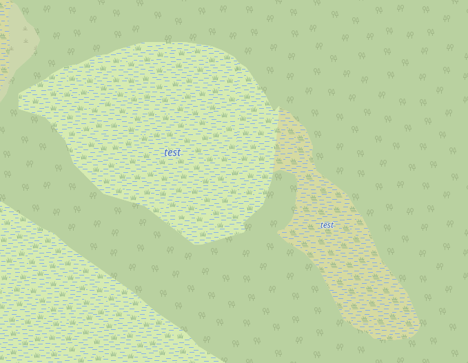
To make it clearer, here's a screenshot of the result of a test using
this method:
https://www.torger.se/anders/downloads/Screenshot_2020-12-12.png
OSM-Carto makes one name tag per sub-part instead of just one for the
whole which is both undesired and ugly, but I've come to understand that
OSM-Carto is not really for making good cartography but for a debugging
view where low computational overhead is prioritized over good
cartography. I think that design choice is unfortunate, but not
something I can do anything about, it is what it is. We hope that
"someone else" does the cartography bit. It does become a bit confusing
though when the naming method looks incorrect on the de-facto reference
map that OSM-Carto has become, especially when this naming method is not
documented anywhere. So it seems unlikely that "someone else" will
actually make the rendering correct if there is no documented way of how
the data is organized in these naming situations.
The OSM way seems to be to let individual mappers make their own tagging
to solve the problems they have. This ends up with a fragmented
situation of diverse methods where none is big enough to catch on, and
most mappers just choose the easy way out and just simplify the map so
the simplest already established methods can be used. The easy way out
for me here would be just to ignore that the wetlands are both bog and
marsh and just make everything bog: problem solved by lowering geodata
quality. And I think this is what many mappers do, it's very
unsatisfying to map things that doesn't show up properly on any renderer
one can find in use.
But this time I'll try to be a good OSM citizen and take the lead in
tagging if necessary. I just need to know that the method I choose is
the best so it at least have some chance of survival so that my work
doesn't go to waste. There are more challenges coming up so more
questions will probably land on this list.
/Anders

On 2020-12-12 12:23, Anders Torger wrote:
Sorry, I realize I have a followup question. Is this really the right
way?
There's a difference from the Rhine example. With rivers all the
separate parts are tied together with a parent relation of the type
waterway, and the parts have roles like "main_stream".

In the wetland case as described, there is no parent relation at all.
The only thing that ties them together is implicitly by sharing
borders and having the same name tag. It seems to me that an
"official" way to edit should tie them together with a parent
relation.

The logical way would be a parent relation with type=wetland (and
actually have the name only there, but no renderer today understands
that, it needs to be on the separate parts as well). What should the
roles be? The most logical way would be to leave role field empty. To
summarize:
Suggested method of how to name a wetland that has more than one
sub-type:
* Prerequisite: each sub-type (marsh, bog etc) is a polygon (or
multipolygon if required,
  for example if there's an inner water or forest) which shares
segments with the
  neighboring sub-type, ie the wetland is a single entity.
* Put the name on each part, same for all
* Create a relation with type=wetland (no sub-type) and include all
parts with role
field empty, also name this relation with the same name (although no
current
  renderer will care)

What do you think about this way? JOSM thinks it's fine at least, I
get no warnings :-).

(Note that there's another case that can be solved with just a single
multipolygon, when there's a single sub-type but the parts are
separated, so each part can be an outer, this is also (quite) common,
although more common for waters and islands than wetlands. The special
thing with the discussed case is that it's a single entity all parts
bordering to the next)

On 2020-12-11 20:55, Anders Torger wrote:
Thanks I'll do it this way then, this actually works and even gets
rendered, although with OSM-Carto it becomes a name tag in each
separate part so not exactly beautiful, but the data is there.

/Anders

On 2020-12-11 18:07, Christoph Hormann wrote:
Anders Torger <[email protected]> hat am 11.12.2020 17:07
geschrieben:
The least bad way I've come up with is to just name all polygons
belonging to the same wetlands the same,
That is widely considered to be the correct way.  It is established
practice that mapping things like forest, wetland, farmland etc. can
be split to differentiate tagging (like leaf_type, wetland type, crop
etc.).  The name tag is then applied to all components.  Same as for
waterways or roads where you can also split and apply the name to the
components.

This also matches the general concept in OSM that names are typically
local properties and only locally verifiable.  The Rhine river is
called Rhein in Koblenz but Rhin in Strasbourg and Rijn in Rotterdam.
_______________________________________________
Tagging mailing list
[email protected]
https://lists.openstreetmap.org/listinfo/tagging
_______________________________________________
Tagging mailing list
[email protected]
https://lists.openstreetmap.org/listinfo/tagging
_______________________________________________
Tagging mailing list
[email protected]
https://lists.openstreetmap.org/listinfo/tagging