For me, the value "parking_space" what key, single space problem must
be fixed first to say something about "street_side". As it comes to a
vote.
Could you elaborate?
amenity=parking_space can be used as usual within amenity=parking. This
of course also works with amenity=parking/parking=street_side:
https://www.openstreetmap.org/way/849745989
Our proposal doesn't affect the documented use of amenity=parking_space;
you would use it just the same as with parking=surface.
Reading parts over the years about parking.
A lot of people do no see amenity=parking as a good tag for street side
parking.
Mainly prompted by wiki (image) en carto, the visualisation of P.
https://wiki.openstreetmap.org/wiki/Parking street side parking is the only
method in given on this page.
The main tag covering most conventional car parks, coach parks etc. Many
additional tags are listed on this page.
We will always have that opposition.
Also a question for me, must we split the tagging there, when we still can.
amenity is mostly with a sign
https://wiki.openstreetmap.org/w/images/thumb/8/80/NLE04.gif/60px-NLE04.gif
amenity=parking_space can only be tagged on a amenity=parking?
https://www.openstreetmap.org/relation/11650954#map=19/53.21448/5.80418
Why is this a relation and not only polygon tagging. (That is a other
discussion, but rubs against it)
If some, we, not use amenity=parking, how to tag the parking_space as a
value?
There spots, where people park in the verge, on the grass, or other surface
grass_paver, what is permitted. In or outside the residential area. (
"bebouwde kom")
https://wiki.openstreetmap.org/w/images/thumb/b/bc/NLE01.gif/60px-NLE01.gif
have not a effect on the verge, the EU rule is no_parking on the
carriageway. The operating force of a traffic sign may not be expanded.
https://upload.wikimedia.org/wikipedia/commons/thumb/8/8b/Nederlands_verkeersbord_B1.svg/60px-Nederlands_verkeersbord_B1.svg.png.
Outside the residential area "bebouwde kom" it is prohibited to park on the
carriageway, but not on the verge.
How do we do that with parking, amenity=parking?
Also the structure of the area:highway methodology, which needs to be
further developed in detail.
All landuse what is used for legally public roads, laid down in a zoning
plan by the Government "bestemmingsplan" should be called landuse=highway,
inside this polygon the objects are area:highway
https://wiki.openstreetmap.org/wiki/Proposed_features/area:highway
https://wiki.openstreetmap.org/wiki/Proposed_features/area_highway/mapping_guidelines

There is area:highway=traffic_island https://overpass-turbo.eu/s/Znt
there should be area:highway=verge, the busbay is also not well documented.
https://wiki.openstreetmap.org/wiki/Key:shoulder the polygon equivalent is
area:highway=shoulder.
https://wiki.openstreetmap.org/wiki/Key:verge the polygon equivalent is
area:highway=verge (verge:access:motorcar=no when parking on the verge is
expressly prohibited.)
But there is this used area:highway=parking_space, and not for only one
space. What a space should be.
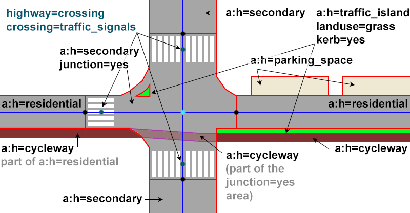
https://wiki.openstreetmap.org/w/images/4/42/MarekXjunctionExampleWithTagging.jpg

area:highway is a used key.
All these parking area, should get a tag area:highway, but which? Or both
amenity=parking. Or is amenity parking only for lots.
https://overpass-turbo.eu/s/Zns ["area:highway"="parking_space"] or is it
area:highway=service service=parking_space if it is one space, with multiple
not drawn in space, service=parking.
That is why I wrote.
For me,
The search for good cohesion.
_______________________________________________
Tagging mailing list
[email protected]
https://lists.openstreetmap.org/listinfo/tagging