Being a Sierra Club member in California, it seems to me that the Yosemite
Decimal System (YDS) [1], originally created by the Sierra Club is made to
order for this. Classes 1 through 3 are basically hiking, 4 is transitional and
5 is technical climbing. My understanding having been exposed to this for
decades is slightly different from that in Wikipedia mine are:
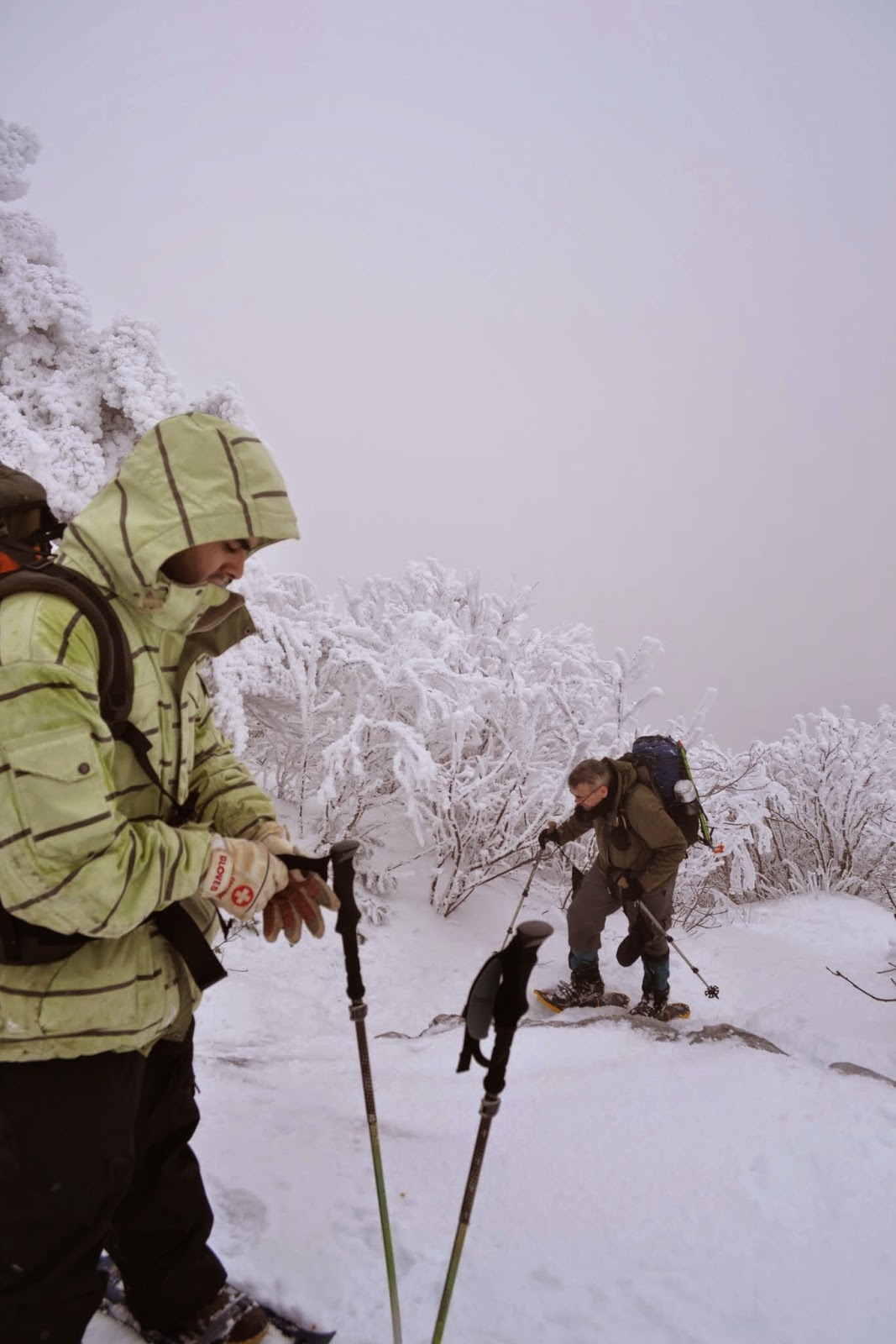
1 - No special gear or equipment needed. If not the equivalent to a city
sideway in difficulty, it is very close.
2 - Uneven, loose or other surfaces where good hiking shoes are advisable.
3 - You may occasionally need to use a hand to steady yourself in difficult
areas.
4 - Climbing or scrambling but low exposure and/or low risk of injury such that
safety equipment like ropes are not required.
5 - Climbing requiring technical skills and equipment.

Class 5 was divided into 10 levels (thus a “decimal” system) but has been
expanded to well more than 10 sub levels over the years as techniques and gear
have evolved. But that is off topic when dealing with hiking trails. I think
for most of what I’d map as a trail we are dealing with classes 1 through 3. In
Kevin’s example system, the trail with a toddler would be a 1 and the other two
examples would be either 3 or 4.

I only see one mention of YDS in the wiki [2] and only a few uses that seem to
use it in TagInfo [3] likely because the various 5 class sub-levels are
associated with climbing [4][5] and many people seem to be unaware of classes 1
through 4.

Cheers,
Tod

[1] https://en.wikipedia.org/wiki/Yosemite_Decimal_System
[2] https://wiki.openstreetmap.org/wiki/Climbing#Grading
[3] https://taginfo.openstreetmap.org/search?q=yds#keys
[4] https://taginfo.openstreetmap.org/keys/climbing%3Agrade%3Ayds_class
[5] https://taginfo.openstreetmap.org/keys/climbing%3Ayds_class

> On May 23, 2020, at 4:59 PM, Kevin Kenny <[email protected]> wrote:
>
> On Sat, May 23, 2020 at 5:42 PM John Willis via Tagging
> <[email protected]> wrote:
>>
>> =path is such a horrible catch-all tag and one that is extremely entrenched
>> - I am surprised no one has implemented a path=trail subtag, similar to
>> sidewalk, so we can separate all the hiking trails and other “hiking” paths,
>> and then apply different hiking limitations you wouldn’t expect to find on a
>> sidewalk or playground way.
>>
>> Mixing trails and sidewalks in the path key is as horrible as mixing up
>> runways and train tracks in a “highway=not_car” way.
>
> Yeah. But it's so entrenched that trolltags are probably the only way
> out of the mess. And sac_scale is _surely_ not the right trolltag! The
> problem with sac_scale is that it's an impossible scale. I'm told that
> https://youtu.be/VKsD1qBpVYc?t=533 is still only a 2 out of 6 on that
> scale, and that https://www.youtube.com/watch?v=3y5_lbQZJwQ is still
> only a 3. Note that one misstep on either of those trails can easily
> mean death.
>
> Confusion on what to expect from wilderness trails abounds. Hardly a
> year goes by without someone from New York City driving up to do one
> of the Catskill or Adirondack trails, expecting something like a
> developed trail in a suburban setting, and winding up dead, from
> either a fall or hypothermia.
>
> This is a `highway=footway surface=ground`:
> https://www.flickr.com/photos/ke9tv/34048181 - a toddler can do it
> with ease.
>
> So is this: https://www.flickr.com/photos/65793193@N00/3183604743/ -
> requires good physical condition, a head for heights, and some
> technical hiking skills. Shorter hikers may be at a disadvantage.
>
> And this:
> http://3.bp.blogspot.com/-oOi7vvpUt0Q/VJnktGwmMDI/AAAAAAAABoY/xYpcKlxPPqI/s1600/DSC_3880.JPG
> - requires winter mountaineering skills and a modicum of technical
> equipment (at least snowshoes or skis, ski poles, crampons, ice axe).
>
>
>
> --
> 73 de ke9tv/2, Kevin
>
> _______________________________________________
> Tagging mailing list
> [email protected]
> https://lists.openstreetmap.org/listinfo/tagging
![]() signature.asc
signature.asc
Description: Message signed with OpenPGP
_______________________________________________
Tagging mailing list
[email protected]
https://lists.openstreetmap.org/listinfo/tagging