The amount of time someone spent at an incline is important for some
pedestrians, so I'd use an option that splits the way and sets the incline
tag.
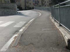
sidewalk=slide might be related to a tag I've wanted for a while. I think I
would personally call that a ramp, so maybe a use of a tag like ramp=yes
would be worth discussing.

There's two big benefits I can name right away:

- It becomes easier to incrementally map l to armchair map these features.
User A tags ramp=yes on a footways (armchair mappable), User B can then use
a QA tool and add incline=up/down (armchair mappable), user C can add
incline=a number (must map on-site).

- It becomes possible to distinguish infrastructure built as a ramp (like
this slide or a wheelchair ramp) from any other segment of footway that
just happens to be steep.

Does ramp=yes seem like an appropriate (hypothetical) tag for this
situation?

On Thu, May 16, 2019, 4:02 PM Alessandro Sarretta <
[email protected]> wrote:

> Hi everybody,
>
> I'm mapping various sidewalks and I'd like to tag the portion of the
> sidewalk that slides down from a higher level to the ground, and then maybe
> goes up again. This happens usually in correspondance with driveway
> entrances (how do you tag them?). You can see an example here
> https://wiki.openstreetmap.org/w/images/thumb/b/b9/Sidewalk_and_zebra-crossing.jpg/240px-Sidewalk_and_zebra-crossing.jpg
>
> For wheelchair accessibility it would be important to characterize it with
> an incline tag: when the incline value its e.g. >5% the accessibility can
> be considered limited, and so on.
>
> One of course could split the sidewalk for a 1 m section and assing a
> specific incline value to it; this might lead to a very fragmented way and
> sometimes it would be easier to simply add a node and assign an incline
> value to it. Even the simple information that there's a portion of the
> sidewalk not horizontal (without a specific value) can be useful.
>
> I've thought about using a node on a footway=sidewalk with
> *sidewalk=slide* + *incline=<value> *or something similar.
>
> I thought also about using the tag kerb, but in this case it isn't a real
> intersection with the road, so it doesn't seem to be appropriate to me.
>
> Do you have any experience on that or suggestions?
>
> Thank you in advance,
>
> Ale
>
>
> _______________________________________________
> Tagging mailing list
> [email protected]
> https://lists.openstreetmap.org/listinfo/tagging
>
_______________________________________________
Tagging mailing list
[email protected]
https://lists.openstreetmap.org/listinfo/tagging