I'm not granting tagging rights for trailheads.... if anyone thinks it's
worth mapping a place as a trailhead, be my guest!  I know that in the US
lots of trailheads have been tagged, I can find many on lists, there are
operators of these places keeping lists so others can find and select... so
some people think they are worth mapping.
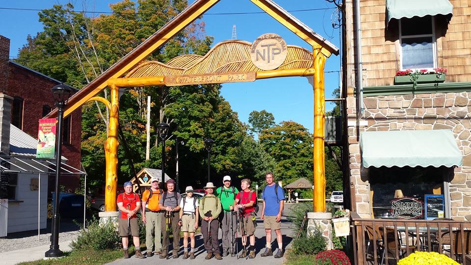
Same in Nederland, though the population density and the terrrain are very
different. And in fact there are lots of sites with lists and maps and
details, but none have the quality and completeness that OSM now offers.

The minimum requirements here are: free parking space, some kind of
landmark, at least 2 bicycle routes and two walking routes, and an
information board or stand. And waymarks for route directions.

My requirements are: visibly designated for the purpose, and a name for the
trailhead, at least something like "TOP Groenlo" for the TOP in Groenlo
where all the routes start.

Op do 3 jan. 2019 om 00:36 schreef Kevin Kenny <[email protected]>:

> On Wed, Jan 2, 2019 at 2:58 PM Peter Elderson <[email protected]> wrote:
> > Designated starting point for multiple routes into a nature area.  There
> is a designed marking pole or stele, information boards, seats or benches,
> free parking space nearby.
>
> > The operators are governmental bodies. They publish the lists on
> recreation websites. Each province has its own list.
>
> What of these are required characteristics, and what are merely usual?
>  A lot of trails in the US are operated by non-government volunteer
> organizations, and there's no central registry. (Some of these
> organizations are more organized than others.)
>
> > Some other examples have been mailed by others, I thought?
>
> Some of the examples were mine, and I thought that you had rejected
> them as not being 'trailheads' because of a relative lack of
> facilities - typically at most a few parking places, a notice board
> and a guidepost.
>
> So, a largish collection from my area, none of which quite meet your
> criteria:
>
> I would imagine that
> http://www.nptrail.org/wp-content/uploads/2015/03/NPT-Section1.jpg
> might qualify, since it has all the above (parking, information kiosk,
> seats, and I presume that arch would qualify as a 'marking pole or
> stele') - except that it's the jumping-off point for a single long
> (220 km) route, not multiple routes.
>
> 1. I'd imagine that https://www.flickr.com/photos/ke9tv/16998968697
> would be pretty marginal, since it's got just a wide compacted spot on
> the roadside, with a notice board and register book, and it has no
> name. It's very typical of what we'd call trailheads around here,
> though. The notice board and register are present at the ones in
> wilderness areas, because there's a legal requirement to register when
> entering and leaving a wilderness area, and at the ones belonging to
> the land conservancies (they use visitor statistics in grant
> proposals, and ask that visitors register as a courtesy). For this
> particular trail, the operator is a private conservancy, so it's
> nongovernmental.
>
> 2. https://www.flickr.com/photos/ke9tv/14041171575/ was another
> example I gave earlier - the start of two or three trails, but in that
> case it's just a hairpin turn on a 4WD road, with enough natural bare
> shale to park a few SUV's, and paint-blazed trails leading off. I seem
> to recall that one got the answer, 'not a trailhead - having one or
> more foot trails heading off into a nature area doesn't make it a
> trailhead.' The operator here is indeed the state, and the trailhead
> is listed in a state database.
>
> 3. I'd imagine that https://www.flickr.com/photos/ke9tv/29381789461
> would also not be a 'trailhead', because it lacks parking (it's lawful
> and reasonably safe to park on the side of the road, but not right
> there in the snowplow turn-around), seating, signage, a register, or
> anything except for a paint-blazed trail. Still, it's an access point
> to a major long-distance (600+ km) trail. The operator is a private
> volunteer organization, and the trail there follows easements over
> private land. I don't know of a database listing this trailhead,
> although it shows up in the trail's guidebook.
>
> 4. https://www.flickr.com/photos/ke9tv/19584241442 is even more
> primitive. It's got a compacted verge big enough to park a few
> vehicles, and that little sign on the tree says 'TRAIL HEAD PARKING.'
> The notice board and register are a few km back on the road, because
> that's a grandfathered road in a designated wilderness, and so drivers
> have to register on entry. (There's a ranger station at the nearest
> entry gate.) The trailhead is state-owned, operated by the Adirondack
> Mountain Club, and listed in the state database. There are no
> facilities other than the sign and the blazed trail departing.
>
> 5. https://www.flickr.com/photos/ke9tv/10282292144/ lacks parking,
> seating, or a notice board. (Again, there's possible roadside parking
> not too far away, and I suppose you can sit on the highway guard
> rail.) There is a notice board and a register, but because of problems
> in the past with vandalism, they're about half a km into the woods
> along that access trail. The operator is the state.
>
> 6. https://www.flickr.com/photos/ke9tv/8463648046 has signage, and a
> notice board, but only roadside parking and no seating. The access
> trail from there is popular enough that the grass is well trodden down
> in summer and there is an obvious snowshoe track in winter. The notice
> board is disused. The operator is the county, which has no trailhead
> database. The county doesn't require visitor registration, so there's
> no book.
>
> 7. https://www.flickr.com/photos/ke9tv/28554220940 has an obvious
> paint blaze and plastic trail marker. There is only roadside parking.
> The notice board is clearly abandoned, and the register book is
> nowhere to be found. The operator is the state, but this trailhead is
> not in its list. The trailhead, however, does appear in the trail's
> guidebook.
>
> The only one with a toilet is the one by the Northville Arch. (There
> may be a thunder box[1] somewhere near 4. I didn't look, not being in
> need of one just then._
>
> None of these would be in the National Park Service database that
> someone thought was a register of all trailheads in the US.
>
> So, what among these qualifies as a 'trailhead'?  All of them are
> designated points from which a hike, ski or ride might start. Only one
> (the Northville arch) has the full set of facilities that you list,
> but it's among the volunteer-maintained ones, and I'm not sure whether
> the landowner is the village, or one of the adjacent businesses. I
> seem to recall that the arch was erected by the Chamber of Commerce (a
> private consortium, as are Chambers of Commerce in general over here).
> None of them has all the attributes you mention.
>
> All of these, except for the first, are documented access points to
> major trails, hundreds of km long, including the Appalachian Trail,
> the Finger Lakes Trail, the New York Long Path, and the
> Northville-Placid Trail. They're not local anomalies for minor nature
> areas, they're pretty typical of wild-forest or wilderness trailheads.
>
> [1] A thunder box might als be called a "loo with a view."
>
> https://st.depositphotos.com/1518508/3320/i/950/depositphotos_33209389-stock-photo-wilderness-toilet.jpg
> is typical. For some reason, I don't seem ever to have photographed
> one myself.)
>
> _______________________________________________
> Tagging mailing list
> [email protected]
> https://lists.openstreetmap.org/listinfo/tagging
>


--
Vr gr Peter Elderson
_______________________________________________
Tagging mailing list
[email protected]
https://lists.openstreetmap.org/listinfo/tagging