I believe I understand exactly what you mean, David, and I fully
agree. We could start by advising people to use the values for
smoothness in their descriptions. If so many people agree that the
current values are inappropriate, let's write a proposal for the new
values, get it approved (should be easy) and recommend against using
the old (current) values.
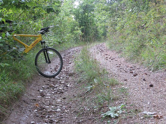
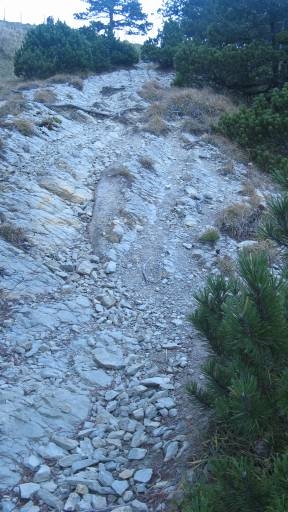
Even if we do so, I think both tags are necessary to assess beforehand
how safe it is to pass, or how fun it would be (if that's what you're
seeking). So you can use both to describe different aspects of the
surface. (I kinda think you want to pursue a single tag - either
smoothness or track, but not both -, that may be an impossible task
considering all the discussions we've had so far. I tried to propose
that actually, and there was no interest.)

Regarding what Vali said, I would have tagged most of the examples as
paths. But I'm biased by the fact that, in Brazil, we have agreed to
use highway=track only when the way is wide enough for a car to get
through. I understand that the distinction between path and track is a
much bigger, sort of unresolved issue.

Below is how I would have tagged each of Vali's examples. (I usually
don't add mtb:scale and sac_scale on roads, but do on tracks and
paths.) I'll borrow the opportunity to mention how my proposal to the
OSRM (car profile) would have treated these cases (tell me your
suggestions), listing two factors it tries to guess: a maximum safe
speed, and a level of effort (for which 1 means no effort, 2 means
you'd rather choose a way 2x as long if its surface was very smooth,
solid and well maintained). Tell me what you think:

http://oi59.tinypic.com/33fala8.jpg
highway=path + smoothness=off_road_wheels + tracktype=grade2 +
mtb:scale=3 + sac_scale=mountain_hiking + surface=rocky
* Expected safe speed (if wide as track): ~4kmph, limited by smoothness.
* Effort level: 15, set by smoothness.

Rationale: it's not wide enough for a car, so it's not a track. If it
were, it would need to be an off road vehicle (just high clearance
won't do if I'm aiming at "safety"). The material is not entirely
solid, not an even mixture, it's in between, so grade2.

http://oi58.tinypic.com/t7iiht.jpg
highway=path + smoothness=off_road_wheels + tracktype=grade2 +
mtb:scale=2 + sac_scale=mountain_hiking + surface=rocky

http://oi60.tinypic.com/1zmmrlt.jpg
highway=track + smoothness=high_clearance + tracktype=grade2 +
mtb:scale=1 + sac_scale=mountain_hiking + surface=rocky
* Expected safe speed: ~10kmph, limited by smoothness.
* Effort level: 7, set by smoothness.

http://oi61.tinypic.com/6ozcdw.jpg
highway=track + smoothness=high_clearance + tracktype=grade2 +
mtb:scale=2 + sac_scale=mountain_hiking + surface=rocky

http://oi59.tinypic.com/4htmag.jpg
highway=path + smoothness=robust_wheels + tracktype=grade4 +
mtb:scale=0 + sac_scale=hiking + surface=earth
* Expected safe speed (if wide as track): ~20kmph, limited by
tracktype and smoothness (both yield the same limit).
* Effort level: 4, set by smoothness. (Tracktype is almost the main
factor, with an effort level of 3.)

http://oi62.tinypic.com/11v5z13.jpg
highway=path + smoothness=robust_wheels + tracktype=grade4 +
mtb:scale=1 + sac_scale=mountain_hiking + surface=earth

http://oi60.tinypic.com/15zgldc.jpg
highway=path + smoothness=robust_wheels + tracktype=grade4 +
mtb:scale=0 + sac_scale=hiking + surface=earth

The first case is actually a dillemma I had for the OSRM proposal. I
did consider smoothness=off_road_wheels as routable for an average car
hoping this way I wouldn't derange many people by making their tracks
suddenly inaccessible in OSRM. I'm not sure about this decision, maybe
the speed should be even lower or the effort much higher to avoid them
more, or maybe they shouldn't be routable at all for an average car.

Another note: the tagging I did above is following the "text" in the
wiki, but the pictures for smoothness at the "bad" end of the scale
seem out of sync. I think a high clearance vehicle can go through a
way as in the image for off_road_wheels
(http://wiki.openstreetmap.org/w/images/4/4f/Jena_Trackexample_profile.jpg),
that an off road vehicle can go through a way as in the image for
specialized_off_road_wheels
(http://wiki.openstreetmap.org/wiki/File:Mountain-track5.jpg). I also
think that a tank or an ATV (specialized_off_road_wheels) can go
through "impassable"
(http://wiki.openstreetmap.org/w/images/1/16/Smoothness_impassable.JPG).

On Thu, Mar 20, 2014 at 7:36 PM, David Bannon <[email protected]> wrote:
>
> Vali, great contribution to the discussion.
>
> The three photos sort of span the things we are talking about, confused
> a little by the fact that they don't really suit 'cars' !
>
> tracktype= is really focused on [cars, suv, 4x4, trucks] but useful info
> for bike or walkers.
>
> I sort of think 'smoothness=' is your best tag. Its descriptions are
> excellent, as I have mentioned, I have issues about the word
> "smoothness" and the assigned values. Sigh....
>
> Now, you can be very very evil and consider rendering when tagging. Its
> called "tagging for renderers", punishable by death but happens all the
> time. I have never seen a map that shows smoothness=.  Some evil people
> consider this fact when choosing which tag to use.
>
> Maybe, folks, we should take more notice of the smoothness= tag ?  If
> promoted it could be whats needed ?
>
> David
>
>
> On Thu, 2014-03-20 at 22:26 +0100, vali wrote:
>> Hi
>>
>>
>>
>> I tried to figure out how to tag these tracks "the right way" but
>> after reading the wiki and this thread it seems the tracks discussed
>> are almost like gravel roads or tracks in farmlands. Most tracks here
>> are old (some of them centuries old), very twisty and the maintenance
>> is almost none.
>>
>>
>> I have some pics to show what I am talking about:
>>
>> http://oi59.tinypic.com/33fala8.jpg
>> http://oi60.tinypic.com/1zmmrlt.jpg
>>
>>
>> These should be trackytpe 2 or maybe 1. The first pic is not great,
>> but the track is carved in the stone. The second one is just a track
>> over a stone bed. Stones will not move under a heavy vehicle nor be
>> eroded by rain. Surface tag should be surface=rock (wich is missing in
>> the wiki)
>>
>> http://oi58.tinypic.com/t7iiht.jpg
>> http://oi61.tinypic.com/6ozcdw.jpg
>>
>>
>> These are different from the two before because the rocks are smaller
>> and can get loose. Rock size can be from fist-size to a meter.
>> tracktype? surface?
>>
>> http://oi59.tinypic.com/4htmag.jpg
>> http://oi62.tinypic.com/11v5z13.jpg
>>
>>
>> This kind of track is often found in places with long-time
>> settlements, are centuries old and were made by bullock carts. They
>> tend to be very narrow and twisted. The surface on some of them is
>> smooth (not the one in the pic) and could be made from earth, rocks or
>> a varied mixture of both but I didn't see any of them with just
>> gravel. 4x4 can't get there: they are too wide and, most important,
>> their turning radius is too big. The only suitable motor vehicles
>> there are small tractors or motorbikes.
>>
>>
>> Because of rural depopulation this kind of tracks are becoming paths
>> as the borders start to decay into the track in some areas.
>>
>> Tracktype? surface is earth most of the time.
>>
>> http://oi60.tinypic.com/15zgldc.jpg
>>
>>
>> This one is very typical too. The surface is compacted earth. Is hard
>> and smooth enough to use a normal car there if we only take in account
>> the surface. Tracktype 2 o 3 maybe?
>>
>>
>> Which I try to say here is there should be a way to tag the
>> "drivability" of the track itself to answer: which kind of vehicle can
>> use this kind of track?. Describing the surface alone is not enough
>> sometimes.
>>
>>
>> Bear with me since I am new to OSM in general and even more in the
>> list, but I am very insterested in this topic in particular since the
>> things I plan to map are mostly hiking routes and a lot of the time
>> tracks are widely used.
>>
>>
>>
>> 2014-03-20 18:44 GMT+01:00 Kytömaa Lauri <[email protected]>:
>>         David Bannon wrote:
>>         >"Should I use this road or not ?"
>>         > tracktype= does claim to use that approach
>>
>>
>>         It's a shame that we, the community, don't excel at
>>         documenting. The part about "how well maintained"
>>         on the Key:tracktype page was added later after
>>         the values. There is a connection, but tracktype
>>         wasn't meant to be about "usable or not", but about
>>         the most influential attribute of the road construction
>>         (or lack of, among the easily observable attributes),
>>         of all the attributes that are involved in shaping the
>>         conditions road users see on any ways not up to
>>         the highway standards of the present day.
>>
>>         So it's a description of a scale from "hard materials only"
>>         to "soft materials only". The connection to "maintained"
>>         is variable and complex, but usually the grade is also a
>>         good approximation of the maintenance, but there can
>>         be, and there are, exceptions. One does not usually(?)
>>         maintain a road made of soft sand only, but a track on
>>         exposed solid rock is "hard materials only" even if nobody
>>         ever raised a finger to "build" the way.
>>
>>         A user can deduce expectations from the combination
>>         of surface=*, tracktype=*, their vehicle, season, and
>>         local weather - and in some cases, even smoothness=*
>>         if the rocks, roots and potholes prevent some users.
>>
>>         There can not be anything beyond "soft materials only",
>>         that's quicksand. If many mappers have actively used
>>         the tag to describe their assessment of "should i use or
>>         not", the meaning of the tag has diverged from the
>>         use in other regions, and we'll never know which one
>>         was meant. (Luckily, there's seldom any major difference
>>         - it's probably be the rare extreme cases that can be in
>>         disagreement.)
>>
>>         If mappers want to tag a subjective "should i use it",
>>         it should be some other tag if the hard/soft materials
>>         scale doesn't suit them. But for which road user?
>>
>>         --
>>         Alv
>>         _______________________________________________
>>         Tagging mailing list
>>         [email protected]
>>         https://lists.openstreetmap.org/listinfo/tagging
>>
>>
>>
>> _______________________________________________
>> Tagging mailing list
>> [email protected]
>> https://lists.openstreetmap.org/listinfo/tagging
>
>
>
> _______________________________________________
> Tagging mailing list
> [email protected]
> https://lists.openstreetmap.org/listinfo/tagging


--
Fernando Trebien
+55 (51) 9962-5409

"The speed of computer chips doubles every 18 months." (Moore's law)
"The speed of software halves every 18 months." (Gates' law)

_______________________________________________
Tagging mailing list
[email protected]
https://lists.openstreetmap.org/listinfo/tagging